Showing posts with label national parks. Show all posts

Wednesday, December 12, 2018

Cedar Breaks National Monument


This post is part of my series on the National Park System. One of my goals while the kids are still at home is to visit as many of the National Parks and Monuments in the Western United States as we can.

Southern Utah may very well have the most concentrated set of natural wonders anywhere. (If you combine Utah with northern Arizona, I bet you would.) Within a few hours drive of each other are no fewer than five national parks and numerous national monuments. The parks get most of the press - and traffic: Zion, Bryce, Arches, Canyonlands, and even Capitol Reef.

But don’t sell the monuments short. They are often less crowded and more akin to wilderness. One great example of that is Cedar Breaks National Monument. I am embarrassed to admit that in 30 years of visits to Utah, it tool until 2016 to finally visit this little gem. I had actually driven by it a few times on the way to Bryce, but had never actually stopped there.

My wife attends the Utah Shakespeare Festival (usually with a friend) every year for the last few, and she actually beat me to Cedar Breaks - she and the friend took a morning trip there, because it is pretty close to Cedar City. Our whole family traveled there in 2016 both for some of the fall plays, and to visit the various parks in the area.

Cedar Breaks is often called a “little Bryce.” It has the same basic features: a canyon system with hoodoos and bright colors. It is steeper, though, and there aren’t really trails down into the canyons except on the one end. It is also quite a bit smaller and intimate. The biggest difference, though, is the setting. The rim of Bryce is at 8,000 feet elevation, which is cold enough during the winter. But at 10,000 feet, Cedar Breaks tends to be cold and windy even in the summer - and it closes entirely during the winter season. Because of the altitude, the wind, and the temperatures, visitors should come prepared. Bring a jacket, even in the summer. Just in case.

One thing the altitude does bring is marmots. I see these in the high sierra all the time, but it was nice to see them here too. (For those unfamiliar with them: if squirrels played football, marmots would be the offensive line and the nose tackle.)

The views at Cedar Breaks are fantastic, and they can be reached with a few moderate or easy hikes, depending on how far you want to go. The rangers are friendly and helpful; and, because of the low number of visitors, they actually have time to talk.

If I were advising someone new to the area as to a trip here, I would recommend the following: First, plan on coming during the summer or early fall, when the snow is gone. Cedar Breaks doesn’t open until the roads are clear. Second, plan to catch a play or two at the Shakespeare Festival, which runs (conveniently) during most of the time Cedar Breaks is open. Third, since Cedar Breaks can be seen in one day, plan to visit other nearby places. In cooler weather, Zion and Snow Canyon State Park are lovely. (Try to avoid Zion on weekends, though - it can be super crowded.) If the weather is hot, Bryce will be a cool relief. I also recommend seeking out Kanarraville Falls, a little slot canyon with a beautiful waterfall. 


 There were quite a few wildflowers - even in September. It's a short growing season. 

 Marmot.

 Yes, that's a Bristlecone Pine. Not as old as the ones in California or Nevada, but striking nonetheless.


 I love the contrast of colors.

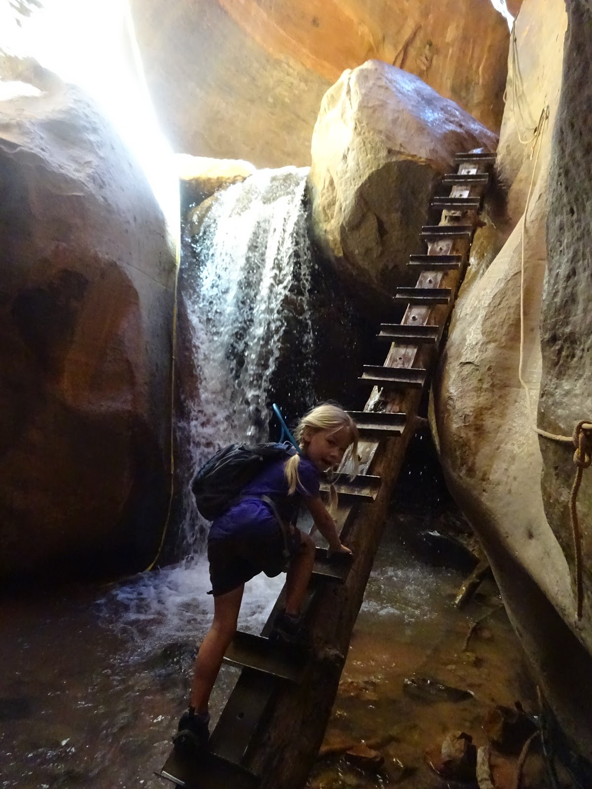
 And, for good measure, here is Kanarraville Falls.
My youngest was age 5 when this picture was taken.

Wednesday, September 26, 2018

Channel Islands National Park

This post is part of my series on the National Park System. One of my goals while the kids are still at home is to visit as many of the National Parks and Monuments in the Western United States as we can.

When I was a kid, we used to camp throughout the year. During the hot days of summer, we would head for the mountains. During the cooler part of the year, we would camp at the beach. For the most part, we liked to camp at a place called Emma Wood State Beach, just west of Ventura. The campground is right on the rocky beach, so you can sit and watch the ocean during the day, and see the lights of the oil rigs at night. If it is a clear day, you can see across the channel to the string of islands about 20 miles offshore. 


(l-r) Anacapa Island, Santa Cruz Island, Santa Rosa Island
Picture taken from Rincon Parkway, 2015.

(l-r) Platforms "Gina," "Gail," "Gilda," and "Grace." 
Picture taken from Rincon Parkway, 2015.
The infamous Platform A is further to the west by about 20 miles. 
I'm pretty sure we crossed between Gail and Gilda on our boat ride to Santa Cruz Island.

 There are eight total Channel Islands. Santa Catalina Island is inhabited - and is a premier scuba diving destination. San Nicholas and San Clemente Islands are owned by the US Navy, which uses them for live-fire exercises. Ironically, the Navy is also committed to protecting some endemic species on these islands. It appears the occasional shelling is less damaging than the goat, sheep, cattle, and pig ranching that was done in the late 1800s. San Nicholas Island is also the location for the real-life story told in Island of the Blue Dolphins.

The remaining five islands, (west to east) San Miguel, Santa Rosa, Santa Cruz, Anacapa, and Santa Barbara, are all part of the Channel Islands National Park. Anacapa and Santa Cruz were designated a National Monument back in 1938. The others were designated as part of the newly-created National Park in 1980. However, because they were private land, they had to be purchased (at exorbitant cost) from the landowners. This process took until well into the 1990s - and the last of the feral pigs weren’t exterminated until a few years ago.

Human habitation of the larger islands dates back at least 10,000 years, but it wasn’t until the 1800s that the Mexican government granted large estates on the islands to ranchers. Over the years, goats, pigs, cattle, and especially sheep were raised on large ranches. These wreaked havoc on the local flora and fauna. 

 Scorpion Ranch, Santa Cruz Island. Now part of the national park.

What really started the push to preserve the islands, however, was a human-caused catastrophe. In 1969, what was then the largest oil spill in US history occurred. Even today, it is the third largest in US history. Over a hundred miles of coastline was fouled, thousands of birds died, plusa large numbers of fish and marine mammals. Southern California today is home to 23 million people - it was lower then, but it was still a highly populated area.  The catastrophe was enough to spur significant action. Our modern environmental laws stem from this incident. The EPA. The Clean Water Act. Actually, pretty much everything the current Administration and the GOP wish to dismantle. Here in California, the incident led to state legislation such as the California Environmental Quality Act, and the formation of the California Coastal Commission. In addition, since that time, California has refused to permit any further offshore drilling within its 3 mile limits. You can read more about the spill here. 

 I'm pretty sure this is "Gilda," taken from the boat on the way back from Santa Cruz Island, 2018.

The spill also led to efforts to preserve the unique ecosystems of the Channel Islands - a rare bit of wilderness just a few miles from one of the most populous areas of the United States.

One unique feature of the park is that more than half of it is underwater. Significant portions of the ocean surrounding the islands is a nature preserve, leading to vibrant underwater ecosystems and fantastic diving locations.

I had previously been scuba diving off of Anacapa Island, but had never actually set foot on the land. Recently, the kids and I took a boat out to the largest island, Santa Cruz Island, for a day of hiking and exploration.

Santa Cruz Island is interesting in that only a quarter of it is owned by the Federal Government. The rest was donated over time by the original owners to the Nature Conservancy. This portion of the island is kept largely wild, with visitation restricted. The Federal portion is more accessible, with hiking trails and a campground.

The Channel Islands are also an interesting demonstration of Charles Darwin’s famous theory. Darwin noted that isolated island populations of animals developed unique traits over time. In particular, island creatures tend to grow either larger than usual, or smaller than usual. This is a phenomenon which is seen all around the world, and the Channel Islands are no exception.

While hiking, we saw several examples of this phenomenon.

First is the Island Fox. Regular sized foxes are common in North America. Kit Foxes are a much smaller version. Where I live in Bakersfield, you can find San Joaquin Kit Foxes, which are the size of medium-small dogs. But on the Channel Islands, you can find even smaller foxes - more closely related to full sized foxes than true kit foxes - an endemic species which nearly went extinct as a result of human interference. Here is what happened: pigs were brought over to the islands, and became feral. The pigs destroyed fox burrows, but also attracted Golden Eagles, which ate both the piglets and fox cubs. As a result, the foxes were on the brink of extinction - only 100 or so were left. The Nature Conservancy and the NPS worked together to save them. The pigs were finally exterminated by 2006. Native Bald Eagles were reintroduced to the island. These were territorial, and kept the Golden Eagles away - and Bald Eagles eat fish, not foxes. Recently, Island Foxes were removed from the Endangered Species List - a fantastic success story. You can read more here. Island Foxes lack the usual fear of humans, so they can be a nuisance. They will steal your food if you are not careful. On the other hand, they are not aggressive and won’t bite unless handled. And, they are seriously cute. Roughly the size of cats but weighing less, they have a lot of cat-like mannerisms, making them irresistible for kids.

 Island Fox, Santa Cruz Island, 2018

Another endemic species with a small size is the Island Fence Lizard. These are smaller than their close relative, the Western Fence Lizard. There were several other bird and reptile species which are considered sub-species unique to the island, but the differences are more minor.

Finally, there is the Island Scrub Jay. There are two mainland species of Scrub Jay here in the western United States, the California Scrub Jay, and the Woodhouse’s Scrub Jay. The Island version looks similar to the California version, but is significantly - 50% - bigger. It also is a strikingly rich blue, and has a different call than other jays. DNA evidence suggests that it split from its mainland cousins about 150,000 years ago - which coincides with when the islands likely were separated from the mainland. 

 Island Scrub Jay, Santa Cruz Island, 2018

In addition to the abundant wildlife underwater, on the land, and in the air; Channel Islands National Park contains great views, memorable hikes, and beautiful clear water.

The easiest way to get to the islands is via boat. While I know people who have kayaked the 10-20 miles across the channel, the average mortal will generally want to catch a ride with Island Packers. Scuba divers can take a trip on one of several boats to a variety of destinations. I haven’t gone diving much since we had kids - just sporadically - and I am not up on which boats are the best these days, so ask around a bit.  

Scorpion Bay from the trail. 
 The north coast of Santa Cruz Island from Cavern Point.

Anacapa Island from the boat on the way to Santa Cruz Island.


Common Dolphins in the Santa Barbara Channel. 
There are an estimated 10,000 of these that live here. 
The eastern side of Santa Cruz Island. 

Anacapa Island from Santa Cruz Island.
Anacapa is actually three separate islands separated by narrow channels.
View from the Smuggler's Bay Trail. 
An abandoned oil rig near the centerline of the island.


Sunday, August 26, 2018

Kings Canyon National Park


This post is part of my series on the National Park System. One of my goals while the kids are still at home is to visit as many of the National Parks and Monuments in the Western United States as we can.

In 2017, 4.3 million people visited Yosemite National Park. Less than one-sixth that number visited Kings Canyon National Park - and the overwhelming majority of those visited only the Grant Grove area - or merely entered at that gate and drove south to Sequoia National Park. (The two are administered as a single unit.) The number of visitors to the canyon itself is barely one-third of the visitors to Grant Grove - and that is only during the peak summer and fall months when the road is open.

This is an interesting state of affairs, because Kings Canyon is actually quite a bit like Yosemite. A glacial valley with towering granite cliffs, green meadows, a refreshing river, a scenic drive in...why is it less popular? One reason likely is that Yosemite has bigger waterfalls. Another is that Yosemite is famous, while Kings Canyon is known mostly to true wilderness aficionados. On the one hand, this is a shame, because Kings Canyon is a marvelous park. On the other, well, the lack of crowds is a significant part of the charm.

One interesting fact about Kings Canyon is that the overwhelming majority of the park is wilderness, completely inaccessible by road. For most of the park, you have to hike to get there - and not easy, short hikes either. From any number of trailheads, it is possible to hike 50 to 100 miles before you cross a road. And these go up and down passes at up to 14,000 feet, traverse mile-high cliffs, and generally conspire to defeat all except the most committed of backpackers. The Kings Canyon backcountry is world-renowned for its beauty and isolation. It is kind of odd to think that all this is less than 100 miles from some pretty large cities in the most populous state in the Union.

I first visited Kings Canyon before I had kids - and I visited the backcountry only. We backpacked in from the east side of the Sierra Nevada, over Kearsarge Pass (nearly 12,000 feet) - which is the park boundary. We camped a couple nights on Bubbs Creek, which is one of the upper branches of the canyon. It wasn’t until I had three kids that I took them into the valley itself for a day of hiking and exploration. Later, I would backpack starting on that end, and bring the kids back to camp.

Kings Canyon is one of the deepest canyons in the United States. If you count the highest peaks (at 14,000 feet) and the lowest depth, it is nearly two miles deep. This isn’t a canyon like the Grand Canyon, with obvious rims, but it is quite deep, and the lower portion is pretty sheer.

The portion you can visit by car is the South Fork of the Kings River canyon. There is a lodge and several campgrounds at Cedar Grove, and a number of trailheads throughout the canyon. There are a few good day hikes, depending on your stamina, and many more backpack adventures.

I recommend camping in the canyon, as it is beautiful, fairly quiet, and lets you see the many moods of the canyon. At minimum, walk Zumwalt Meadows, visit Roaring River Falls, and hang out somewhere with a view. I also like the overlook trail up Hotel Creek. Strong hikers will enjoy the 9 mile round trip to Mist Falls and back - which is also the start of the Paradise Valley backpack - one of my favorites. There are so many options, and I have only explored a few despite the many times I have visited.

For campers, only one of the campgrounds is reservable. There are two more (plus a tents-only group camp you can also reserve), and those rarely fill up completely except on holiday weekends. If you get there Friday morning, easy to get a site. Better selection is available on Thursday. Or just come during the week. 

***

 Our first visit in May, 2008. Ted (age 2), Cordelia (age 3), and Ella (age 5). 

 Near East Lake, off Bubbs Creek, John Muir Wilderness, 2010

Bubbs Creek canyon, John Muir Wilderness, 2010

Looking south toward the Sphinx, South Fork Canyon (Paradise Valley), 2011

 Monarch Wilderness, 2012

 Kings Canyon from the Hotel Creek Overlook, 2012. (Picture by Ella, then age 9.)

Roaring River Falls, 2012. 
Ella (age 9), Cordelia (age 7), Ted (age 6), Fritz (age 4)

 The Sphinx, from below Mist Falls. Kings River Canyon, 2018
Ted (age 12), Cordelia (age 13), Ella (age 15), Fritz (age 10), cousin, me, Lillian (age 7)

 Western Tanager, 2018.

Zumwalt Meadow, 2018.

Thursday, May 24, 2018

Si Se Puede! - Cesar Chavez National Monument


This post is part of my series on the National Park System. One of my goals while the kids are still at home is to visit as many of the National Parks and Monuments in the Western United States as we can.

It is kind of strange to think that we had never been to the National Monument closest to us. Cesar Chavez National Monument lies a mere 30 odd miles east of Bakersfield, and we drive right by it every time we head out to Utah, Arizona, or even just Red Rock Canyon State Park. Perhaps one reason for the neglect is that it is a fairly new monument. Created in 2012 by President Obama, it was intended to eventually be part of a larger National Historic Park with several locations throughout central California. (That will require an act of Congress, which seems unlikely as long as the Republicans are in power and are dominated by a xenophobic ideology.)

It is difficult to escape knowledge of Cesar Chavez and the United Farm Workers if you live in California’s central valley. The famous Table Grape Boycott and worker strike started in Delano, about 30 miles north of Bakersfield. Chavez’ name is on almost as many streets, buildings, and schools as Martin Luther King Jr.’s here in California. From The Grapes of Wrath to Esperanza Rising, the history of farm labor is inseparable from the history of California. The stories are told in histories, fiction, and legend. Helen Fabela Chavez, Cesar’s wife - and a labor legend in her own right - lived here in Kern County until her death less than two years ago. Dolores Huerta is still with us, and as feisty as ever.I have friends who worked the fields, and some of our local bench and bar grew up in farmworker families.

Just a bit of background, for those who aren’t as familiar with the story. Mexican farm workers have been working the fields, vineyards, and orchards of California ever since the Spaniards showed up and established missions. California was part of Spain, then Mexico for nearly 100 years. During that time, migrant workers went back and forth freely across the border. Actually, let me be honest: it has never really stopped. Up until the immigration changes in the 1920s, anyone could cross that border (except certain known criminals) and settle here. Or come, work, and return as they wished.

Things changed during the Dust Bowl. With white migrants from Oklahoma and Kansas and other Great Plains states, suddenly there were extra workers - which meant the brown ones had to go. During the Mexican Repatriation, around two million Mexican Americans (about 60% of which were American citizens) were forcibly removed. But that didn’t mean that immigration stopped. Rather, as the Okies largely moved out of farm labor, and into other professions, the vacuum was filled once again by Mexican migrants. And also Filipino immigrants. (To this day, Delano has a large Filipino population. There are two Senior Centers, which I used to visit during my GBLA days. One was predominantly Filipino Americans, while the other was mostly Mexican Americans.)

Fast forward to 1965. Our section of California grows the vast majority of the table grapes grown in the United States. Grapes are a big deal here. Large family and corporate farms dominate the industry, and all rely on farm labor for the tremendous work required to tend and pick the vines. Due to an unfortunate loophole in the law (and lax enforcement of the laws that existed), workers were being paid less than minimum wage - and the growers were demanding lower wages even as a record harvest rolled in.

The Filipino union started the strike, but Chavez joined in soon after. The two unions merged to form the UFW soon after. You can read more about the Delano Grape Strike and Boycott here. The boycott would become an international blacklisting of California table grapes, and the pain would eventually be felt by the growers. Chavez would fast for 25 days to draw attention to the issue, with Robert Kennedy, among others, eventually joining the fight. A march from Delano to Sacramento - 200 miles! - drew nationwide press. The strike continued for five long years, but eventually, the growers gave in, and union representation was put in place. Laws were also changed.

Later, Chavez had a vision for a headquarters for the UFW that would also serve as an American version of the Kibbutz - a collective community. A property that appeared suitable came on the market, and Chavez and the UFW made plans.

The history of this place is fascinating. They had a video on it at the visitor’s center. Originally, in 1913, the property was the site of a rock quarry run by the Kern County Highway Department. Later, in 1917, the quarry was shut down, and the site was converted to a tuberculosis sanitarium, run by the California Bureau of Tuberculosis. (Yes, we actually had that back in the day!) Quite a few buildings were added over the years to “Stony Brook Retreat,” and it became quite the compound. It’s in a beautiful spot in the foothills of the Sierra Nevada, with clean, dry air and moderate temperatures year round - the perfect place to try to beat the consumption.

Alas, by the 1960s, admissions were way down - darn you, penicillin! - and the State shut down the operation. The County then had this property on its hands, and decided to auction it off.

Chavez knew, however, that he was hated by the powers that be in Kern County. (We still have some of that Good Old Boy network going - and a few really horrid politicians...although by no means all of them.) Thus, the chances of him being permitted to purchase the property (in 1970) was pretty much zero. The County went so far as to refuse to let anyone from the UFW view the property.

A little strategy was needed. Edward Lewis, a film producer, offered to help. He got permission to view the property, and took along one of Cesar Chavez’s brothers...who posed as a chauffeur. (I can’t find exactly who he was - he was in the film, but not on the NPS website about the site. I think I have the relationship correct.) Lewis then bid on the property, won, and then turned around and leased it to the UFW with the intent of eventually selling it to them.

The County officials were furious, and refused to accept payments for a few years, before eventually giving in. But the deed was done, and there was no helping it. The UFW got its property.

The compound was renamed Nuestra Señora Reina de La Paz, and the UFW moved its headquarters there. Chavez would also live there for a number of years. From 1970 to 1984, the site served as a community as well. Times changed, and many of the buildings have become a bit run down. You can’t tour them, although some are still retained by the UFW, and are available for conferences and stuff.

A part of the site was donated to the National Park Service, and is now the Cesar Chavez National Monument. You can read more about La Paz on the NPS website.

The part you can visit consists primarily of the visitor’s center and the gardens. Within the visitor’s center is a reconstructed farm worker house, which is all of six feet by eight feet, with no plumbing, and a single bed. Often more than one family would share the house. This is what the growers offered their workers - and the housing and food ate up their meager wages - and often more than that, which is why children worked the fields rather than attend high school. Also there is Cesar Chavez’ office, and a collection of historic photographs and artifacts from the early days of the UFW and its predecessors.

The gardens are interesting. Not particularly large, they consist of three parts. The first part as you enter is filled with plants important to California, from a giant native blue oak (likely a few hundred years old) to roses (the Rose Parade flowers are sourced from Shafter and Delano) to grapes, naturally.

The middle section contains the gravesites of Cesar and Helen Chavez, as well as a monument to the UFW. It is a peaceful and beautiful place.

The third section was inspired by Cesar Chavez’ birthplace, Yuma, Arizona. It contains cacti, agave, and ocotillo, all of which were in bloom.

It won’t take long to tour: we spent about an hour and a half there, and some of that was because I was chasing birds with my camera.

To make a day of it, like we did, I recommend heading to Tehachapi for lunch, then touring the historic train depot. Finally, drive up to the Tehachapi Loop, a section of train track where a full loop is made, and most freight trains will be on top of themselves 77 feet below. It is a busy line - really the only artery from the Southwest to the Central Valley - and trains pass every half hour or so. We even got to see a “Meet,” where two trains pass on the Loop.

I am hoping that eventually Congress finishes the task, and adds the Delano headquarters and other sites to a larger National Historic Park, the way they did for the World War Two Homefront sites. Farmworker rights still remain an unfinished task, and our racist and dysfunctional immigration laws are part of the problem, giving employers extra leverage against exploited workers. (I highly recommend The American Way of Eating by Tracie McMillan for an inside look at the realities of farm work.) The recent Supreme Court decision allowing employers to force employees into individual arbitration rather than group together in a class action is a terrible step in the wrong direction. I cannot but believe that there is more need for unionization than ever before, in the face of increasingly powerful (and more monopolistic) corporate employers, with no perceived duty to their workers. Chavez began the work, but there is so much still to do.

One final thought: the slogan, Si Se Puede! is so very familiar, yet its significance isn’t always appreciated. Chavez helped popularize it, but credit belongs to Dolores Huerta for coming up with it in the first place.

Barack Obama essentially “borrowed” it with his “Yes We Can” speech, and that certainly is one possible translation. More literally, it might be read as “Yes, it CAN be done.” But as the exhibits point out, both of these miss that the “we” part is crucial. The meaning is “Yes, it can be done if we work together. WE can do this.” The collective action is important. Strength and power in numbers. And in community.

***

Pictures, of course: 

"Huelga!" - "Strike!" Chavez named his dogs Huelga and Boycott. 
This is one of the original signs for the "National Farm Workers Association," one of the two unions that merged to form the UFW.

My youngest, Lillian, working on her Jr. Ranger book. She was horrified at the crowded conditions. And the lack of bathrooms. 

 Chavez' Office. 

 A picture of the march on Sacramento - this covered an entire wall. Very impressive. 

 The gravesites. As my wife said, "it isn't often I see one of my patients' graves." 

 A major score here. This is a male Hooded Oriole - what a beautiful bird.

 Cactus in the Arizona garden. 

 This Red-shouldered Hawk and California Scrub Jay were in a dead treetop right by the old Sanitarium.

 Trains on the Tehachapi Loop.


Tuesday, May 1, 2018

Fossil Beds of Oregon and Idaho


This post is part of my series on the National Park System. One of my goals while the kids are still at home is to visit as many of the National Parks and Monuments in the Western United States as we can.

Last summer, on our epic trip to see the solar eclipse, we saw Great Basin National Park on the way up. We also hit a couple of interesting national monuments related to fossils.

The western United States is well known for its many fossil sites. The reason for this is pretty simple: it is dry. The desert nature of much of the American West has meant that there are large areas without forests, prone to flash flooding and thus erosion. This, combined with the fact that the climate was wetter in the past, has meant that fossils were formed, but are now uncovered and visible. More likely than not, plenty of other places on our planet have fossils that will never be discovered because they are buried too deep for erosion. (At least in anything close to our lifetimes - another billion years, and who knows?) These same factors have made it much easier to study geology: things aren’t buried in forests and sediment.

Once I decided on eastern Oregon for our eclipse viewing, it was pretty easy to see that there were some obvious destinations we could add in. First, Great Basin, since it was pretty much on the way there. If we went through Great Basin, then it would be right on the way to hit Hagerman Fossil Beds - at least a short visit.

Our eclipse site was just a couple hours or so from John Day Fossil Beds, which looked worth a more extended visit. We found a campsite in the mountains to the west of the monument (important during the summer heat), and set aside a couple days to explore it.

Hagerman Fossil Beds National Monument

Hagerman isn’t a bit monument, and you can’t see the fossils in the ground without a dig permit. You can drive through the monument, which is on the west bank of the Snake River east of Boise. The grass-covered bluffs are quite pretty. You can see some of the covered wagon tracks of the Oregon Trail still there over a hundred years later. (Nobody died of dysentery, fortunately…)

Other than these picturesque views, you have to go to the visitor’s center for a short movie on the history. And bones, of course.

Hagerman’s fossils are from the Cenozoic Era - the age of mammals. Specifically, they are from the Pliocene, roughly between two and six million years ago. That’s pretty recent in geological time, but also well before the Pleistocene, with its iconic wooly mammoths and sabertooth cats (fossils from which are preserved at the La Brea Tar Pits in Los Angeles - one of my haunts as a kid.)

The Pliocene had plenty of interesting creatures though. Most notable at Hagerman is the hagerman horse, the first true one-toed horse. It isn’t just the specific creatures, though. It is the fact that Hagerman contains a great variety of fossils, enough to enable fairly good reconstruction of the ecosystem. Also giant otters, which I find cool.

You can see Hagerman in a couple hours easily, and the docents are more than willing to show you around the pictures and bones and reference materials. 

 Hagerman Horse

 Mastodon skull

John Day Fossil Beds

In contrast to Hagerman, which is compact and centralized, John Day Fossil Beds is divided into three units representing just a tiny portion of an absolutely gigantic fossil formation. The formation spreads across much of eastern Oregon, and is bigger than several New England states put together. Some of that is private land, some is BLM and other government holdings. But the three units are specifically protected as a national monument. If you want to see all three units (Clarno, Sheep Rock, and Painted Hills) take roughly two hours of driving just to go between them. Yes, that’s a lot of driving. But it is also extraordinarily beautiful backcountry on twisty, steep roads. We even took the truck on some one-lane gravel roads (which are clearly marked - you won’t get lost) and saw some canyons, hidden valleys with little ranches tucked back there, and more. It’s a beautiful place.

Like Hagerman, John Day Fossil Beds is all about the Cenozoic Era. However, because the elevations are more varied, John Day spans most of the Era, from 66 million to about 3 million years ago. That’s pretty nearly the entire age of Mammals. This was enough time for the climate to change dramatically as the Cascade Mountains rose in the west, blocking the rainfall. It went from jungle to redwood forest to oak forest to grassland, and eventually to its current desert.

The means of fossil preservation varied with time as well. Many of the best preserved fossils are from lahars - lava ash mud flows. Those are pretty nasty in person, clearly, but are fantastic for preserving fossils. Particularly those of the delicate parts plants, which don’t always survive sedimentation well. Leaf fossils abound, and are amazingly preserved - you can see them right there on one of the hikes. Leaf fossils are also preserved at the bottom of ancient ponds - more about those later.

There are also lots mammal fossils, from some pretty big and gnarly bears, to the early ancestors of both cats and dogs, back when they were bearcats. Also brontotheres, early horses and deer, and innumerable rodent-like critters. Also four inch cicadas and other insects, which aren’t always preserved well.

It is kind of interesting to see the progression from the older animals to the younger. There is definitely a progression toward modern species as you go.

The plants are likewise fascinating: you can definitely recognize modern flowering plants and pick out modern “types,” if you will. Oaks, elms, birch, redwoods, ferns, and more. But, they aren’t quite right. There are enough differences that the trained eye can see that they are not the exact same species we have now.

The “Dawn Sequoia” is an interesting example. There are innumerable fossils of this - apparently it was widespread in the area. Dawn sequoias are clearly related to modern redwoods and sequoias, but there is a significant difference: they were deciduous. There is a non-extinct example of this in China, a living relative of the dawn sequoia but not identical, but it has been long gone from North America for quite some time.

I mention this plant not just because I love redwoods and sequoias, but because I now possess some of these fossils. There is a high school in a small town that lets you (for a donation) borrow a hand trowel and dig in the hill behind the school. It is a series of sandstone layers with sediment in between, which makes for easy digging. The layers are from an ancient shallow lake. It was fun to bring out rocks and split the layers to find clear leaf or stick fossils in between. I am so glad the ranger recommended this and that we found time to do it.

The Sheep Rock unit is the one with the visitor’s center, and it is a good place to start, with videos about the formation of the fossils, their discovery, and the human history of the area. It also has a great collection of fossils on display. (Many others are located in museums around the United States - I saw a good one at the Los Angeles Natural History Museum recently - and one from Hagerman too.) This is the place to hike to see some mammal fossils in situ. There is also a preserved ranch that is quite pretty.

The Painted Hills unit is more of a scenic experience than a fossil experience. The titular hills are indeed beautiful. (If not for the ever-present wildfire smoke when we were there, I expect I could have gotten some spectacular pictures.) Created by layers of volcanic ash, they to contain fossils, but none are visible to visitors.

The Clarno unit is the most remote, pretty far from anywhere, and accessible only by a long, twisty, scenic road. Not that this is a bad thing - it is a beautiful drive. We made a loop out of it, cutting through a rarely driven back road. The big attraction at Clarno is the remains of a lahar - a hot, wet ashflow that preserved whole ecosystems of plants. Along the trail, you can see leaf and branch prints, petrified wood, and more. These are fossils you can see without barriers, without plexiglass, and in most cases without labels. You have to keep your eyes open, but they are all around. I imagine someone first saw these and felt like they had walked into Aladdin's cave.

John Day Fossil Beds is a bit out of the way, in a forgotten part of the backcountry. But it is definitely worth a visit. I imagine that last year’s eclipse raised its profile, as it was in the path of totality, but visitation will probably go back to being light this year. 


 Sheep Rock


 Rock formation of the Clarno Unit

 One of the many fossils visible from the trail.

 Petrified logs.

 Fossils I dug up.

The Painted Hills Unit. Sadly, a lot of smoke from the wildfires a hundred miles north.