Showing posts with label hiking. Show all posts

Wednesday, December 12, 2018

Cedar Breaks National Monument


This post is part of my series on the National Park System. One of my goals while the kids are still at home is to visit as many of the National Parks and Monuments in the Western United States as we can.

Southern Utah may very well have the most concentrated set of natural wonders anywhere. (If you combine Utah with northern Arizona, I bet you would.) Within a few hours drive of each other are no fewer than five national parks and numerous national monuments. The parks get most of the press - and traffic: Zion, Bryce, Arches, Canyonlands, and even Capitol Reef.

But don’t sell the monuments short. They are often less crowded and more akin to wilderness. One great example of that is Cedar Breaks National Monument. I am embarrassed to admit that in 30 years of visits to Utah, it tool until 2016 to finally visit this little gem. I had actually driven by it a few times on the way to Bryce, but had never actually stopped there.

My wife attends the Utah Shakespeare Festival (usually with a friend) every year for the last few, and she actually beat me to Cedar Breaks - she and the friend took a morning trip there, because it is pretty close to Cedar City. Our whole family traveled there in 2016 both for some of the fall plays, and to visit the various parks in the area.

Cedar Breaks is often called a “little Bryce.” It has the same basic features: a canyon system with hoodoos and bright colors. It is steeper, though, and there aren’t really trails down into the canyons except on the one end. It is also quite a bit smaller and intimate. The biggest difference, though, is the setting. The rim of Bryce is at 8,000 feet elevation, which is cold enough during the winter. But at 10,000 feet, Cedar Breaks tends to be cold and windy even in the summer - and it closes entirely during the winter season. Because of the altitude, the wind, and the temperatures, visitors should come prepared. Bring a jacket, even in the summer. Just in case.

One thing the altitude does bring is marmots. I see these in the high sierra all the time, but it was nice to see them here too. (For those unfamiliar with them: if squirrels played football, marmots would be the offensive line and the nose tackle.)

The views at Cedar Breaks are fantastic, and they can be reached with a few moderate or easy hikes, depending on how far you want to go. The rangers are friendly and helpful; and, because of the low number of visitors, they actually have time to talk.

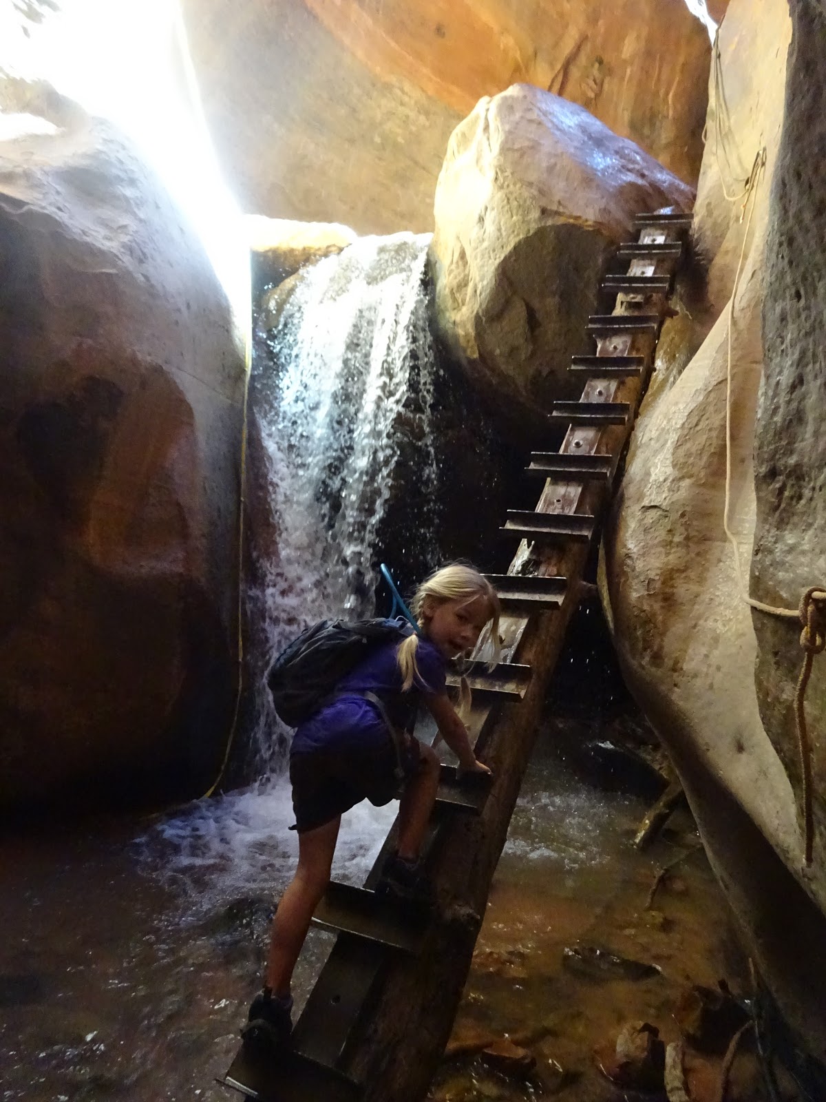
If I were advising someone new to the area as to a trip here, I would recommend the following: First, plan on coming during the summer or early fall, when the snow is gone. Cedar Breaks doesn’t open until the roads are clear. Second, plan to catch a play or two at the Shakespeare Festival, which runs (conveniently) during most of the time Cedar Breaks is open. Third, since Cedar Breaks can be seen in one day, plan to visit other nearby places. In cooler weather, Zion and Snow Canyon State Park are lovely. (Try to avoid Zion on weekends, though - it can be super crowded.) If the weather is hot, Bryce will be a cool relief. I also recommend seeking out Kanarraville Falls, a little slot canyon with a beautiful waterfall. 


 There were quite a few wildflowers - even in September. It's a short growing season. 

 Marmot.

 Yes, that's a Bristlecone Pine. Not as old as the ones in California or Nevada, but striking nonetheless.


 I love the contrast of colors.

 And, for good measure, here is Kanarraville Falls.
My youngest was age 5 when this picture was taken.

Sunday, August 26, 2018

Kings Canyon National Park


This post is part of my series on the National Park System. One of my goals while the kids are still at home is to visit as many of the National Parks and Monuments in the Western United States as we can.

In 2017, 4.3 million people visited Yosemite National Park. Less than one-sixth that number visited Kings Canyon National Park - and the overwhelming majority of those visited only the Grant Grove area - or merely entered at that gate and drove south to Sequoia National Park. (The two are administered as a single unit.) The number of visitors to the canyon itself is barely one-third of the visitors to Grant Grove - and that is only during the peak summer and fall months when the road is open.

This is an interesting state of affairs, because Kings Canyon is actually quite a bit like Yosemite. A glacial valley with towering granite cliffs, green meadows, a refreshing river, a scenic drive in...why is it less popular? One reason likely is that Yosemite has bigger waterfalls. Another is that Yosemite is famous, while Kings Canyon is known mostly to true wilderness aficionados. On the one hand, this is a shame, because Kings Canyon is a marvelous park. On the other, well, the lack of crowds is a significant part of the charm.

One interesting fact about Kings Canyon is that the overwhelming majority of the park is wilderness, completely inaccessible by road. For most of the park, you have to hike to get there - and not easy, short hikes either. From any number of trailheads, it is possible to hike 50 to 100 miles before you cross a road. And these go up and down passes at up to 14,000 feet, traverse mile-high cliffs, and generally conspire to defeat all except the most committed of backpackers. The Kings Canyon backcountry is world-renowned for its beauty and isolation. It is kind of odd to think that all this is less than 100 miles from some pretty large cities in the most populous state in the Union.

I first visited Kings Canyon before I had kids - and I visited the backcountry only. We backpacked in from the east side of the Sierra Nevada, over Kearsarge Pass (nearly 12,000 feet) - which is the park boundary. We camped a couple nights on Bubbs Creek, which is one of the upper branches of the canyon. It wasn’t until I had three kids that I took them into the valley itself for a day of hiking and exploration. Later, I would backpack starting on that end, and bring the kids back to camp.

Kings Canyon is one of the deepest canyons in the United States. If you count the highest peaks (at 14,000 feet) and the lowest depth, it is nearly two miles deep. This isn’t a canyon like the Grand Canyon, with obvious rims, but it is quite deep, and the lower portion is pretty sheer.

The portion you can visit by car is the South Fork of the Kings River canyon. There is a lodge and several campgrounds at Cedar Grove, and a number of trailheads throughout the canyon. There are a few good day hikes, depending on your stamina, and many more backpack adventures.

I recommend camping in the canyon, as it is beautiful, fairly quiet, and lets you see the many moods of the canyon. At minimum, walk Zumwalt Meadows, visit Roaring River Falls, and hang out somewhere with a view. I also like the overlook trail up Hotel Creek. Strong hikers will enjoy the 9 mile round trip to Mist Falls and back - which is also the start of the Paradise Valley backpack - one of my favorites. There are so many options, and I have only explored a few despite the many times I have visited.

For campers, only one of the campgrounds is reservable. There are two more (plus a tents-only group camp you can also reserve), and those rarely fill up completely except on holiday weekends. If you get there Friday morning, easy to get a site. Better selection is available on Thursday. Or just come during the week. 

***

 Our first visit in May, 2008. Ted (age 2), Cordelia (age 3), and Ella (age 5). 

 Near East Lake, off Bubbs Creek, John Muir Wilderness, 2010

Bubbs Creek canyon, John Muir Wilderness, 2010

Looking south toward the Sphinx, South Fork Canyon (Paradise Valley), 2011

 Monarch Wilderness, 2012

 Kings Canyon from the Hotel Creek Overlook, 2012. (Picture by Ella, then age 9.)

Roaring River Falls, 2012. 
Ella (age 9), Cordelia (age 7), Ted (age 6), Fritz (age 4)

 The Sphinx, from below Mist Falls. Kings River Canyon, 2018
Ted (age 12), Cordelia (age 13), Ella (age 15), Fritz (age 10), cousin, me, Lillian (age 7)

 Western Tanager, 2018.

Zumwalt Meadow, 2018.

Wednesday, March 14, 2018

The Fauna of Point Reyes


This post is part of my series on the National Park System. One of my goals while the kids are still at home is to visit as many of the National Parks and Monuments in the Western United States as we can. 

I previously posted about Point Reyes National Seashore from our visit there in 2015. That post contains a good bit about the geological history, as well as some pictures of the various views.

We returned there in November 2017, as my wife in particular loves the coastal forest. This time, I was able to capture some of the animals that call Point Reyes home. Sure, we saw banana slugs last time, but this year, there were elk and elephant seals out. And also bugs and snakes and squirrels. Here are my favorites of the pictures.

 Banded Garden Spider


Banana Slug

 Western Grey Squirrel

Gopher Snake

 Tule Elk

Elephant Seals


Monday, March 12, 2018

Joshua Tree 2018


We are on a three year rotation for desert camping right now. Death Valley National Park, Anza-Borrego Desert State Park, and Joshua Tree National Park. Each has its charms, and each represents a different face of the desert.

Death Valley is vast, with dunes, extremes of temperature and elevation, salt flats, slot canyons, and more. Anza-Borrego is part of the Colorado (Sonora) desert, and is filled with flowers after a wet winter.

Joshua Tree is mostly the high desert - the Mojave. (Although the south part of the park is in the Colorado.)

We returned to Joshua Tree this February, and brought some friends who had never been. This time, while we revisited a number of our favorite places, we also saw some new trails. I was able to take a lot more pictures this time too - last time, my camera died midway through the trip. I was also able to use the longer zoom to capture a number of birds this time.

My previous post (linked above) has more on the natural history of the park, if you want to read further.

Here are the best of the pictures from this trip:


Ladder-backed Woodpecker

Me and the kids. 

Cactus Wren

The iconic Joshua Tree

Desert Cottontail

Looking from the high desert to the low desert.

Greater Roadrunner

 Why you should camp at Joshua Tree...

Saturday, September 23, 2017

Great Basin National Park

This post is part of my series on the National Park System. One of my goals while the kids are still at home is to visit as many of the National Parks and Monuments in the Western United States as we can.

Nevada is one of those states where everyone knows a city or two - and may well have been there - but the vast majority of the state remains unknown and unexplored. For Nevada, Las Vegas is the picture most of us have. Bright lights and golf courses in the middle of a searing desert, slot machines and half-naked chorus girls, Elvis and Liberace. Perhaps a vision of Reno, the scrawny little sister not quite as glam as the big sister. But these are just a very small slice of Nevada. Sure, the population mostly lives in these cities (¾ live in the metro Vegas area), but the great expanses of the state are usually not thought of at all.

This is a shame, as Nevada holds a lot of beauty and open spaces - and isn’t just hot desert either.

The name “Nevada” itself comes from the Spanish and means “snow-covered.” It isn’t really used in isolation, however: it is one half of “sierra nevada” - snow covered mountains. (The highest range in California is indeed the Sierra Nevada.) And the name makes sense. Nevada is the most mountainous state in the lower 48 by several measures. It has more named mountain ranges than any other, more peaks over 10,000 feet, and more than 30 over 11,000 feet.

Most of the state is in the “range and basin” part of the Great Basin Desert. This is a fascinating bit of geology. The Great Basin gets its name from the fact that within it, all rivers drain internally and never reach the ocean. The water all sinks into the ground or evaporates. The Great Basin extends beyond Nevada, of course. The most famous lake within it is the Great Salt Lake in Utah. The portion of California east of the Sierra Nevada - including Death Valley - is also mostly within the Great Basin.

“Range and Basin” is another matter. In the distant past, plate tectonics pushed up the Rocky Mountains. This compressive force raised much of the western North American plate to a fairly high altitude. Later, a shifting earth led to decompressive forces, and a large area spread apart. It didn’t just spread, however, it cracked into a series of blocks. Those blocks then tipped over. Imagine a stack of dominoes on its side in a box a bit too big for it. If they fall over, they will make a series of edges and valleys.

That’s basically what happened to make the Range and Basin formation. The result is pretty interesting to experience in person. Death Valley is the deepest of the valleys formed, but it is just one of dozens. The whole area consists of mountain ranges and valleys running north and south for hundreds of miles. Thus, if you want to go east to west (or vice versa), you go up and down and up and down over and over. But going north or south, you can settle into a fairly flat valley and drive perfectly straight for hours on end with beautiful mountains running on each side.

At the far eastern side of Nevada, about halfway up the state, there is a national park. Did you know that? Not too many do. Great Basin National Park is a fairly recent park - Congress elevated it to National Park status in 1986, during the Reagan administration. (You know, in those halcyon days when Republicans still believed in protecting wilderness rather than just despoiling it for profit…) Before that, it was known as the Lehman Caves National Monument - designated as such by president Warren Harding. (And that’s about the only good thing I have to say about Harding, who probably was the most corrupt president in American history. Although we may be about to set a new record.) The caves are indeed worth protecting, but there is more too.

Great Basin National Park contains Nevada’s highest mountain, Wheeler Peak, at 13,063 feet. Okay, so that is debatable. Boundary Peak is on the California-Nevada border, but it is considered a sub-peak of Montgomery Peak in California. Make of that what you will. Wheeler Peak is notable for being easy to summit - there is a trail all the way to the top, and you do not need rock climbing or mountaineering skills. I didn’t get a chance to hike it this visit, but I do wish to hike it next time. I have yet to summit anything over 13,000 feet, so this one is definitely on my list. 

 Wheeler Peak is the one to the right.

The peak itself is connected to one of the longer mountain ranges, but it stands far above the rest. From the east side (which is where the access is), it appears to rise out of nowhere in a flat valley. 

 Looking west from Baker, NV. Wheeler Peak is in the center background.

On the upper flank of the mountain, at near the 11,000 foot line, is one of two ancient Bristlecone Pine forests. The other is in the White Mountains (also Range and Basin) in eastern California. (I have visited there - I may have to write about it eventually.) The Bristlecone Pine is the oldest living non-clonal organism. Some of the trees here are nearly 5,000 years old. Bristlecones are really amazing to see in person. Because of their slow growth in inhospitable environments, they twist into fantastic and surreal shapes as they grow old. Most of the tree may die, while just a sliver of bark covers one side - and this sliver will continue to grow for thousands of years in some cases. Great Basin NP is a good place to see these trees. However, I prefer the California location both because it is closer to me and because there is a much larger and accessible grove so you can see more trees up close. But by all means go see the ones at Great Basin.
My boys with a Bristlecone about 3200 years old. The left side is still growing. 

 
This is the iconic tree that graces many postcards. It is dead now, but it has stood like this for over a thousand years. These trees do not decay quickly, and some of the wood here is over ten thousand years old. This is one of my favorite shots of all the ones I got.
 
Other things to see include a small glacier - we hiked most of the way before impending thunderstorms threatened. The mountain makes its own weather, so summer storms are a common occurrence. The forest is also lovely, with lots of Engelmann Spruce, which we don’t see much in California. 


 Small glacier at the head of the cirque.

 Engelmann Spruce cones.

 Clark's Nutcracker

 Wild turkeys

 One of my favorite pictures. 

 Some really big ears.

 A magical aspen forest

 Meadow, forest, cirque, and Wheeler Peak on the right.

 The best part of the park, however, is probably the cave. The Lehman Caves are located near the “base” of the mountain, at around 6,800 feet elevation. This statement should give an indication of how high the valleys are in Nevada. Anyway, the cave is pretty amazing. I love caves, and have been in quite a few, mostly in California, but also in Arizona, Tennessee, Texas, and Oregon. I think that of all the ones I have seen, Lehman is the best. It is pretty large, but the passages are narrow enough that most of the formations are close enough to see very well. And the formations! It’s not just that they are nice, but that there is such a wide variety. Pretty much anything you see in a cave is there, including rarer formations like “cave shields.” (Google the term, and Lehman Caves will come up…) I have been in caves with more of each formation. For most formations, I can think of specific examples in other caves that are fantastic. But I can’t really think of any other cave with all of them in the same place. 
 Cave formations
Cave Shield
 
Unfortunately, because we saw this park on our way to see the solar eclipse, we only had one day to explore it. I hiked about six miles in addition to the cave, but it would have been nice to have had time to explore more - and maybe even hike to the peak. The campgrounds seem rather nice, but you can’t reserve them, so it might be risky to drive up and hope. We reserved a site at a local RV park, which was okay as a base camp, but not spectacular as a campsite. When we return, I will probably camp some place on the way up, like Cathedral Gorge State Park, then get up early and try to grab a site on a weekday morning.

Also important for planning purposes: the nearest (and pretty much only) town is Baker, Nevada, which is extremely small. Count on bringing your food, as options are limited.  


Tuesday, June 20, 2017

Zion National Park

This post is part of my series on the National Park System. One of my goals while the kids are still at home is to visit as many of the National Parks and Monuments in the Western United States as we can.

I have a particularly special relationship with Zion National Park. I believe I was age 11 or 12 when I first visited - very briefly. We were on our way home from the Grand Canyon, having seen first the south rim then the north rim, and we decided to drive through the park on the way to St. George. I don’t think we even had time to drive the canyon itself, so we saw the east part of the park and the tunnels and not a whole lot more. But it was enough that we determined to come back and soon. It must have been later that year or maybe the next spring that we planned a trip solely to see Zion, and hiked a few of the shorter trails.

That was the beginning of a love affair that brought us back to Zion at least twice a year. Living first in Los Angeles, then near Frazier Park, and finally in Bakersfield, St. George was all of six and a half hours away, and the park less than an hour from there. Often, we would leave at midnight, drive straight to the park for an early start, hike until mid afternoon, then soak in the hot tub at the hotel, hike the next day, and drive back the day after, for a long weekend of at least ten miles of hiking and exploring. Each time, we would try to take someone who had never seen Zion with us.

I remember that first time at age 12 ascending Angel’s Landing. We were fairly inexperienced at strenuous hiking, and we were so sore afterward that getting to the second floor at the hotel was painful. But the views were so spectacular, we purposed to hike that route as often as we could. Angel’s Landing remains one of my favorite hikes - and it has been both thrilling and terrifying to introduce the kids one by one to it.

(The last half mile is on a knife edge with sheer dropoffs literally 1500 feet straight down on each side. You have chains to hang on to - it isn’t for the faint of heart. The heights didn’t bother me as a kid. Watching my kids now, it is a whole different ballgame.)

I also remember the time when I was a teenager when we hiked the Kolob Arch trail in a day. The 15 miles wasn’t the problem - it was fairly flat. It’s that the whole trail was this deep soft sand. We were so dead by the end, then we had to hike up about 400 feet of elevation to the trailhead - and a summer thunderstorm blew through. Soaked, hoping not to get hit by lightning, and dead exhausted. Good times.

After I moved out in my early 20s, we had a bit of a gap in our visits. Life got busy, I wasn’t flush with cash, and I had a girlfriend who I couldn’t exactly take along, as much as I wanted to. (Both of our parents would have strongly disapproved of such a scandalous thing…)

After we got married, things were obviously different. We visited together during our first year of marriage. Of all the odd things to remember about that trip, I recall watching the Lakers and Kings battle it out. (The end of the 2000-2002 dynasty.) But also, it was Amanda’s first trip up - where else? - Angel’s Landing. (Her dad is a legendary hiker, but he cannot do heights at all.)

Our next trip was when our eldest child was a year old - and Amanda was six months pregnant with our second. (Yeah, our first three kids are ridiculously close in age. Crazy times.) I had Ella on my back in a backpack and Amanda was rather gravid. So naturally, we tackled a trail 10 miles round trip with 2000 feet of climb. Because we could. We both remember her blowing by some college aged guys who gave her dirty looks because they couldn’t keep up. I just about died hanging with her myself. (In fact, my knees hurt so much on the downhill that I worried I was going to have to give up hiking. Instead, I made a lifestyle change toward regular exercise, taking up first soccer then running and making sure I did it 3-4 times each and every week. It made all the difference in the world, and the kids and I hike 120-150 miles together each year these days.)

Since then, we have gone back more or less every other year. My oldest two daughters have been up Angel’s Landing with me, and all the kids have gone to the overlook just before the chains on their own two feet. Last year, in our most recent visit, the two of them went partway up the Narrows with me, which was a fun adventure.

So what is Zion? To put it one way, it is a gigantic fossil. The sandstone cliffs are 3000 feet tall - they are petrified sand dunes from the ancient past. Actually, the entire area is a remarkably intact section of the geologic column. You can go from the bottom of the Grand Canyon to the formations on the mountains above Bryce Canyon National Park and traverse nearly a billion years in history.

The layers at Zion are particularly thick, and they are revealed by the action of the Virgin River, which has carved a slot through the sandstone, making a dramatic and unforgettable canyon. Even taking the shuttle through the canyon drive is a spectacular experience, but you really must get out and hike to get the full experience. Don’t expect solitude, but the spectacular views are worth it. Also, just like anywhere, the further you get away from the road, the fewer people. A short hike like the Emerald Pools (which you should do) will be crowded. The top of the overlook on the East Rim is less popular because of the long and strenuous hike to get there. Likewise, if you take the road toward the Kolob reservoir, most of those trails are empty during the week. The Kolob section of the park is also a great place to hike, with fewer people. The cliffs aren’t as high, but you get some excellent slot canyons.

Zion has always been a popular park, but the last decade or so, crowds have increased a lot. It is worth it to visit during the week, if you can - and definitely NOT during Spring Break. (They had record crowds, and despite an excellent shuttle system, parking was full by 8 AM many days.) The best times to visit are in Spring and Fall, but the park has its charms other times of the year. If you go in summer, hike early, and bring a lot of water. The sandstone concentrates the heat, and there isn’t much shade. I haven’t been there in the winter, but I think it could be interesting then as well.

If you have the time, there are also other places to see in the surrounding area. If you are there in the summer or fall, Kanarraville Falls is an amazing slot canyon we discovered last year. No technical skills are required. If you want solitude, get an early start. Snow Canyon State Park is also a delightful spot, with several short hikes with good scenery. It too is rarely crowded. Bryce Canyon National Park, Cedar Breaks National Monument, and Pipe Spring National Monument are all relatively close destinations. There is also a museum in St. George with dinosaur tracks that were discovered there. It’s a worthwhile place to visit.

Hotels in St. George are ludicrously inexpensive, which is why we don’t generally camp there. Good food can sometimes be difficult to find in smaller Utah towns - St. George is heavy on burger chains, for example. But there are some good exceptions here. We are particularly fond of the Mongolian BBQ place - a little hole in the wall that knows our family well. The Bear Paw Cafe is a good place for breakfast and coffee. Recently, a brewpub opened right by the entrance. Due to quirky Utah liquor laws, you have to have food if you want booze. But the food is solid, and the beer quite good, particularly after a hot hike. I’m happy to see places like these pop up. (One observation from our travels in small towns in flyover territory: brewpubs often have higher quality food - more imaginative and less 1950s - than other places. Yelp is your friend too. The 21st Century is looking to be a golden age for us foodies.)


 From 2004: The very small Ella and a younger, thinner me. The backpack finally died after the fifth kid, but I am still hiking with that hat and stick - both of which I have had since my teens. The hat was from a tourist trap near Zion. The stick is diamond willow from Alaska, which a friend brought back for me. I sanded it and give it a new coat of tung oil finish every few years.

 Amanda in 2004. She was 6 months pregnant with Cora here. This is at the entrance to Echo Canyon, on the East Rim trail.


Ella, Cordelia, and Amanda in 2006. Ted would have been an infant that year. 
This is the Virgin River on the Gateway to the Narrows trail. 

Cordelia, Ella, and Ted on the Emerald Pools Trail in 2009. 

Ted, Ella, Cordelia, and Fritz on the Angel's Landing Trail, 2011.
  Ella, Fritz, Amanda, Lillian, Ted, and Cordelia on the "Walter's Wiggles" section of the Angel's Landing Trail, 2013. 

Real trails have curves. These are the lower switchbacks on the Angel's Landing Trail, viewed from the bottom of Refrigerator Canyon.  
 Ella on the edge of the world. This is the sheer north face of Angel's Landing, 
literally 1500 feet straight down in front of her. (2013)

 Cordelia, Ella, and me in the Narrows, 2016. 

 A better view of Walter's Wiggles, 2016.

 Ella and Cordelia on the top of Angel's Landing, 2016.


 Trying to capture the scope of Zion with a camera is difficult. 
This is one of my favorite pictures, from 2016.